THIS MONTH SEES THE RELEASE OF UPDATE 2 FOR ERDAS IMAGINE 2020. THIS IS AN EXCITING UPDATE THAT INTRODUCES A LOT OF NEW FUNCTIONALITY, PRINCIPALLY TO THE SPATIAL MODELER.
The number of new Earth observation satellites being launched continues to rise and so there is a corresponding increase in the number of formats that IMAGINE supports. Key among these are Pleiades Neo, PlanetScope Level 3 and Sentinel-3, with partial support for ICEYE.
The key new technology in Update 2 is the IMAGINE DSM Extractor module. While Tridicon has performed good service, the new DSM Extractor module features advanced SGM (semi-global matching) algorithms for faster, denser, and more accurate surface generation from stereo imagery.
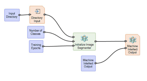
Associated with this is a host of new IMAGINE Photogrammetry operators that allow the creation of complete photogrammetric workflows within Spatial Modeler. The user can now create a block file, associate sensor/camera parameters, add imagery, create tie points, run a bundle adjustment, create a DSM and output ortho imagery. There are also mosaic operators that mirror the advanced functionality of MosaicPro.
Image Chain now has much more functionality with easier histogram manipulation, the ability to use the Drawing and Format tabs with displayed data (including region grow), and profile tools are also now available to use.
If you have ever attended one of my training courses, you will appreciate how much the new Inquire Cursor Live Update option included in this update means to me!
More information about all of the new technology can be found in the online Hexagon Geospatial help, and discussions and example Spatial Models can be found on the Hexagon Geospatial Community These are all definitely worth a look to gain tips and tips to enhance your workflows.
There is, of course, also a wide range of bug fixes. We urge all users to update to this version as soon as possible in order to take advantage of the new technology and stability features provided in this update.
.jpg)