THE ATLANTIC HURRICANE SEASON 2020 HAS NOW OFFICIALLY COME TO A CLOSE WITH A RECORD-BREAKING 30 NAMED STORMS, OF WHICH 6 DEVELOPED INTO MAJOR HURRICANES. THE SEASON BEGAN EARLIER THAN EXPECTED WITH TROPICAL STORM ARTHUR FORMING IN MID-MAY AND CLOSED WITH MAJOR HURRICANE IOTA LAST MONTH. THE SEASON HAS BEEN LONG, HAVING DEVASTATING IMPACTS ACROSS THE WORLD - BUT HOW DID THE EXPERTS FARE IN THEIR PREDICTIONS FOR THE CONCLUSION OF SEASON?
The Atlantic Hurricane Season 2020 has now officially come to a close with a record-breaking 30 named storms, of which 6 developed into major hurricanes. The season began earlier than expected with Tropical Storm Arthur forming in mid-May and closed with major Hurricane Iota last month. The season has been long, having devastating impacts across the world - but how did the experts fare in their predictions for the conclusion of the season?
Back in March, AccuWeather predicted 14 - 18 named storms, with 2 - 4 of those transitioning into major hurricanes. In May, the National Oceanic Atmospheric Administration (NOAA) then made their estimation of 13 - 19 named storms with 3 - 6 becoming major hurricanes, but halfway through an already very active season, they increased their prediction significantly to 19 – 25 named storms.
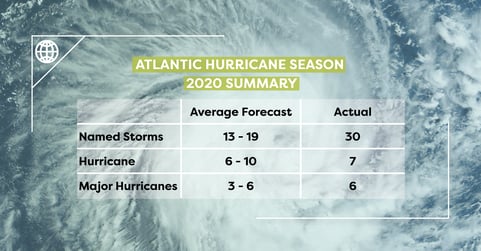
A summary of the predicted and actual figures for Atlantic Hurricane Season 2020.
Following an intense season the previous year, and current ocean and climate conditions, another active hurricane season was expected for 2020. Storms were anticipated to become stronger, and last longer than any previous season, with the development of La Nina leading to an expectation that storm frequency and intensity would continue to rise.
In November the season was expected to come to a natural end, but Hurricane Iota put paid to that, making landfall in Nicaragua on November 16th as a category 4 Hurricane and the strongest of the season, with winds nearing 155mph.
With 6 named storms reaching major hurricane status (Laura, Teddy, Delta, Epsilon, Eta and Iota) this has become the second-highest number of major hurricanes within a season. Most storms hit the Gulf Coast and almost every mile of coastland from Texas to Maine has been affected by a named storm this year.
most storms hit the gulf coast and almost every mile of coastland from texas to maine has been affected by a named storm this year.
Throughout the Hurricane Season, Geospatial Insight track every storm, 24/7 365, to ensure they are fully prepared to react should a client require rapid post-event analysis. Hurricane Laura hit the Gulf Coast near the end of August, and was just one of the many tropical storms that Geospatial Insight reacted to this season. Making landfall as a category 4 hurricane and causing significant windstorm and flood damage across large swathes of Texas and Louisiana, Geospatial Insight’s expert team were able to acquire a range of relevant data sources, including social media coverage, aerial photography, satellite imagery, augmented by specially commissioned drone flights. Analysing this data with a range of analytical techniques, including specifically developed artificial intelligence algorithms, Geospatial Insight were able to complete a detailed property-by-property damage assessment of around 200,000 buildings and deliver, within hours of the hurricane’s impact, a damage categorisation for each property to assist insurance clients to conduct rapid loss estimation and claims triage.
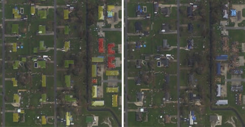
A property-by-property damage assessment, with and without the colour-coded vector building outlines
to showing the destruction caused by Hurricane Laura.
Although the majority of forecasts predicted the 2020 hurricane season to be extremely active, no one could have foreseen exactly how the season would evolve. In a ‘normal’ season, approximately 12 named storms and 3 major hurricanes could be expected, but 2020 has now marked the 5th season in a row of above-average activity. Although we can’t be certain that climate change is the cause of the increasing volume of tropical storms, it does seem to be affecting their severity and unpredictability. Geospatial Insight’s expert response team are highly skilled and experienced in analysing post-event damage of major weather events and are ready to response immediately. For more information on our global (RE)ACT service and how we can assist you, visit: https://www.geospatial-insight.com/products/eventrac/
.jpg)