ON AUGUST 4TH 2020 A VAST MUSHROOM CLOUD HUNG OVER THE CITY OF BEIRUT, CREATED BY A COLOSSAL EXPLOSION IN THE CITY'S PORT. WITH NEARLY 200 PEOPLE DEAD, AND OVER 6,000 INJURED, THIS HAS NOW BEEN CLASSIFIED AS ONE OF THE LARGEST NON-NUCLEAR BLASTS IN HISTORY, CAUSED BY 2,750 TONNES OF AMMONIUM NITRATE STORIED UNSAFELY IN A DOCK-SIDE WAREHOUSE.
The blast obliterated much of the surrounding port area and left a 140m wide crater where the warehouse once stood. Equivalent to a 3.3 magnitude earthquake, significant damage was caused across a radius of 6km from the epicentre of the blast, prompting our catastrophe response team to start collecting valuable data and information to help quantify the scale of the damage caused.
With a number of clients requiring a response within the area, Geospatial Insight’s analysts quickly got to work gathering the best available satellite images, as well as a range of open source data from news and social media. Within 12 hours, images had been acquired and delivered to clients whilst a rapid building-by-building damage assessment was already underway.
Within 12 hours, images had been acquired and delivered to clients whilst a rapid building-by-building damage assessment was already underway.
As airspace opened, Geospatial Insight immediately notified their local drone operator partner who rapidly deployed high-tech equipment over the city. Highly detailed footage was gathered of various parts of the city between the 6th and 8th of August, and added to the growing body of data being used by our analysts to assess the scale and extent of the damage to all property within a 2 km radius of the blast epicentre.
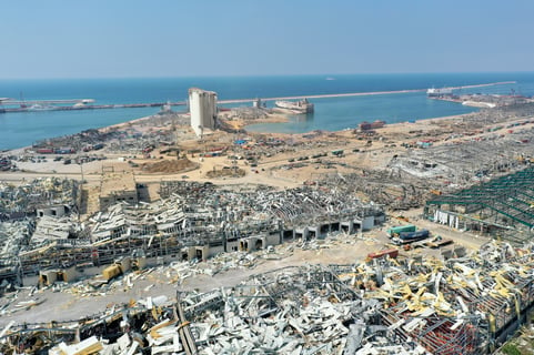
Beirut Explosion. Drone imagery, acquired 5th August 2020
Through this multi-source approach, Geospatial Insight were able to establish a highly accurate representation of damage extent, which showed the true state of the devastation caused in the city.
With a building-by-building damage assessment, Geospatial Insight were able to deliver their clients a detailed picture of residential and commercial property damage across the city, all of which was completed within 72 hours. Using the powerful and intuitive VIP platform, clients were able to visualise, share and interact with the source data and damage analytics as an interactive geospatial database
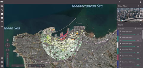
Building-by-building damage assessment, derived from drone imagery - Completed 7th August 2020
Using visual intelligence to respond to CAT events is proving to be the most effective way for insurers to conduct rapid loss estimation, scale their response needs and initiate the claims processes, based upon rapid access to more accurate analytics.
If you would like more information on how Geospatial Insight’s CAT response can support you, please visit: https://www.geospatial-insight.com/products/eventrac/
.jpg)